Table of Contents
This page features proposals for three possible signage projects to be displayed on campus. The intent of these signs is to further visibilize this land’s indigenous people, as well as their traditional knowledges and interactions with the land. Ideally, embedding this information into the campus landscape through signage would make it more accessible and in turn prompt more engagement with these themes throughout our campus community.
Trail Signs
There are three sets of trails on campus: the Upper Lake Loop, Stony Brook/ Long Farm Loop, and Prospect Hill Trails. The three trails are a part of the campus’s living laboratory which allows students to interact with the land surrounding the campus. Classes, students, and the public are constantly interacting with the environment and nature around Mount Holyoke College and there should be an effort to acknowledge and educate visitors about what land the college is occupying. Currently, there are maps and trailheads that explain the paths around campus this plan would place signs or QR codes around campus to educate viewers on the history of the area, information about flora and fauna, the cultural significance of the land, and more. Currently, there are few signs on the trails showing maps of the area and recounting some information about the land and the trails, but they do not recognize the Indigenous history and significance of the land. Below is a trail sign found by the bridge and the crosswalk before entering the upper lake loop.
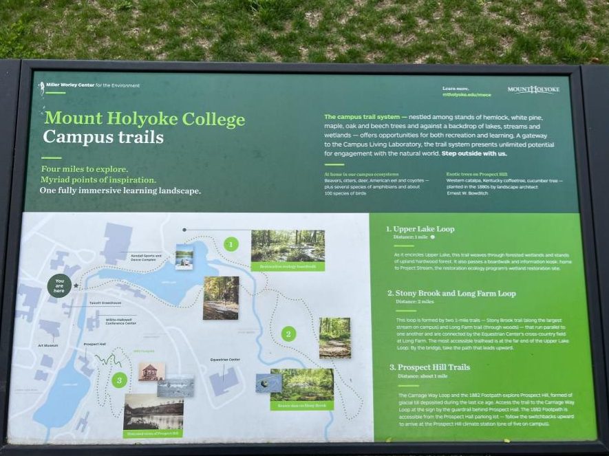
If new signage was implemented on campus, it would be beneficial for the information shared to include what visitors could encounter on these trails, and their Indigenous significance, as well as a general acknowledgment of the land this campus occupies. Many National parks have implemented signage across their visitor centers and trails to acknowledge the history of the now government-owned land. This is a great example among many that our college can model its system off of. Signage could also include the names of the trails on campus along their respective paths, and they could be renamed with Indigenous Nonotuck languages, or if the language is closed to outsiders, with a similar methodology of naming. There are many ways that signage can be changed and implemented on the trails around Mount Holyoke College in a way that acknowledges and respects the land our campus resides on.
Tribe Distances
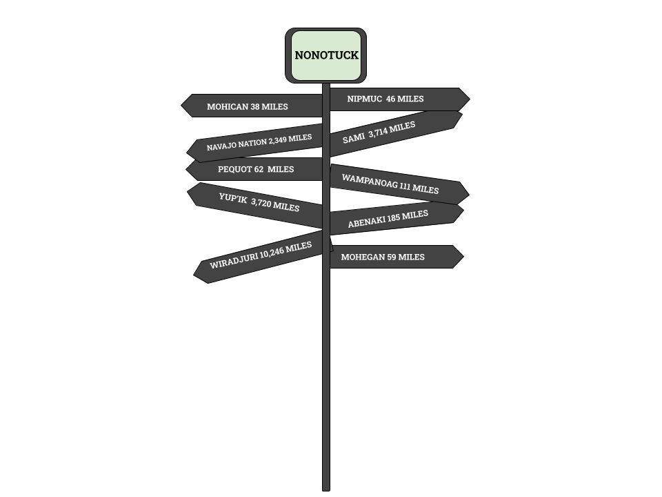
City distance signs can be found anywhere from schools to tourist towns. They are often used to show the distance and the direction of major cities around the world from where you are currently standing. It’s a way to reflect on where you are in the world and how far you are from recognizable places. We wanted to reimagine this sign for our campus. Currently, we have one that sits between the Williston Library and Clapp Hall which tells us we are 3,346 miles from London, England, and 10,012 miles from Sydney, Australia. We wanted to use this sign as a way of acknowledging the land our campus is on today while also acknowledging how far we are from our Indigenous neighbors: the Nipmuc and the Wampanoag to the East, the Mohegan and the Pequot to the South, the Mohican to the West, and the Abenaki to the North. Along with our direct neighbors, we wanted to acknowledge the Indigenous people from our country and around the world, such as the Navajo Nation 2,349 miles South West of our campus, the Yup’ik peoples in the Northwest in Alaska 3,720 miles away, the Wiradjuri people of Australia 10,246 miles away and the Sami peoples in Norway 3,714 miles away. For the surrounding tribes of this area, the distance from the Mount Holyoke campus was measured from the tribe’s cultural center or government building as many do not have recognized reservations and land. For the global Indigenous communities, the distance was either calculated from a cultural center or a recognized reservation or owned land. The image below is representative of what the sign could look like, however, the angles or directions the arrows are pointing are not accurate to where these places are located in relation to the campus.
QR codes
QR codes are a useful tool to spread information in an accessible way for both students and visitors alike. Using QR codes across campus would be an efficient way to spread large pieces of information when there is limited space or time. By eliminating the boundary of signage size, there are unlimited options for how information can be presented and how interactive learning can be. One idea is to collaborate with an Indigenous artist in the area to create a virtual reality image of what the land and campus would look like had there not been colonial interference with the Indigenous relationship with the land. This would be executed by having one or more locations on campus where someone would scan a QR code and their phone would display the image of the land, and as the person turned in any direction from that spot, they would be looking at a virtual rendering of the land from that perspective. Another way to create interactive learning through QR codes and digital teachings is by linking videos or websites from Indigenous communities to the scannable codes in order to share information or lessons. There are endless ways to incorporate technology and the internet into any of these signage projects and any of the campus’s future incentives to Indigenize the campus. Hopefully, as a result, there will be creative solutions to learning in an engaging way on campus.
Sources
Contact Us – Abenaki Nation of Missisquoi Swanton, VT
Stockbridge-Munsee Band of Mohican Indians | Stockbridge-Munsee Band of Mohicans
The Mashantucket (Western) Pequot Tribal Nation (mptn-nsn.gov)
The Land of the Sami, Norway – Experience the Sami culture (visitnorway.com)
Wampanoag Tribe of Gay Head (Aquinnah) (wampanoagtribe-nsn.gov)
Contact Us | CT Phone Numbers & Email | The Mohegan Tribe
Native Village of Nunapitchuk – Tribal Government in Nunapitchuk, Alaska. (yupik.org)