Table of Contents
Important Geographical Places
South Hadley
It is important to note that South Hadley was an unsettled area of Hadley and only established itself in 1775. When looking into records before 1775, you will need to include the surrounding areas.
Slave Streets
Historian Leo Labonte has said that streets in which enslaved individuals lived were at times nicknamed ‘Slave Street’. Some streets in South Hadley that may have had this pseudonym are Morgan Street, Silver Street, and Lyman Street.
Sophie Eastman’s chapter “South Hadley after the Revolution,” In Old South Hadley, 1912, also describes the “road from the house of [David Mitchell] to the present homestead of John Graves” as one of these streets.
For more information:
In Search of Caesar Cambridge, a former enslaved man in South Hadley, Massachusetts
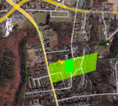
Lot [In the area of what is now Buttery Brook Park]
Pointed out by Leo Labonte as a potential plot of land owned by Freedmen.
See this collection of documents about the free Black community in Hadley, compiled by Erika Slocumb and the Porter-Phelps-Huntington Museums.
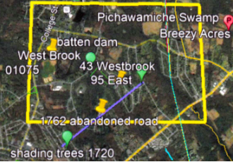
Unofficial Road that may have been used by David Mitchell
Pointed out by Leo Labonte. Shown in the picture below as the purple line.
Woodbridge Tavern (The Yarde Tavern) & 88 Alvord Street
These are potential sites of the Underground Railroad. The building of the Yarde Tavern was also the old congregation house for the First Congregational Church of South Hadley which is now located at 1 Church Street #1, South Hadley, MA 01075.
Sophie Eastman, in her chapter “South Hadley after the Revolution,” In Old South Hadley, 1912, mentions Lewis Clark, the “original George Harris of Mrs. Stowe’s “Uncle Tom’s Cabin”’, as one of the many people to pass through South Hadley’s Underground Railroad.